|
(Northern Athens) |
AH3 Run 1827 Hare: CU Alithia |
Google elevation: 302 metres Trail length: 3.1 km |
|
The
Trail |


|
Before the run |

CU Alithia spontaneously invents misleading details about the upcoming runner's trail
|
The
Run |


The
Circle |


|
The
Taverna |
Magenas Taverna next to the open-air theatre in Ano Melissia
The directions to the hash - for the record |
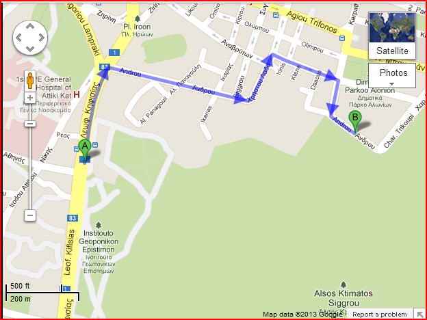
(MAP to Androu Street below text)
Venue: Syngrou Park [NEW PARK TOP ENTRANCE]
From City Center/South:
North on Leof. Kifisias/Λεωφ. Κηφισίας
Turn right onto Androu/Άνδρου (Lovely green graffiti on wall in bold letters "RAPE")
Continue onto Christou Lada/Χρήστου Λαδά
Turn right onto Thiras/Θήρας
Turn right onto Karpathou/Καρπάθου
Turn right onto Androu/Άνδρου - park along both sides of street
From Agios Stefanos/North:
Head southeast on Evaggelou Pentzeridi/Ευάγγελου Πεντζερίδη toward!!! Λεωφ. Μαραθώνος/Leof. Marathonos/Λεωφ. Μαραθώνος
Turn left onto !!! Λεωφ. Μαραθώνος/Leof. Marathonos/Λεωφ. Μαραθώνος
Take the 1st right onto Leof. Marathonos/Λεωφ. Μαραθώνος
Turn left to stay on Leof. Marathonos/Λεωφ. Μαραθώνος
Continue onto Leof. Thiseos/Λεωφ. Θησέως
Continue onto El. Venizelou/Ελ. Βενιζέλου
Turn left onto Char. Trikoupi/Χαρ. Τρικούπη
From North using E75:
merge onto E75 towardATHINA/ΑΘΗΝΑ
Take the exit toward ΒΑΡΥΜΠΟΜΠΗ/VARIMBOMBI/ΑΧΑΡΝΑΙ
Turn left onto Erythraeas
Turn left onto Ag. Saranta/Αγ. Σαράντα |
|
Coords:
Decimal Degrees (WGS84)
Latitude |
Longitude |
38.065767 |
23.816567 |
Degrees, Minutes & Seconds
Latitude |
Longitude |
N38 03 56 |
E23 48 59 |
GPS
Latitude |
Longitude |
N 38 03.946 |
E 23 48.994 |
